The map
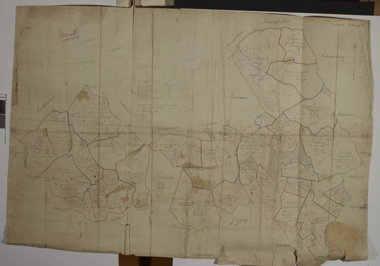
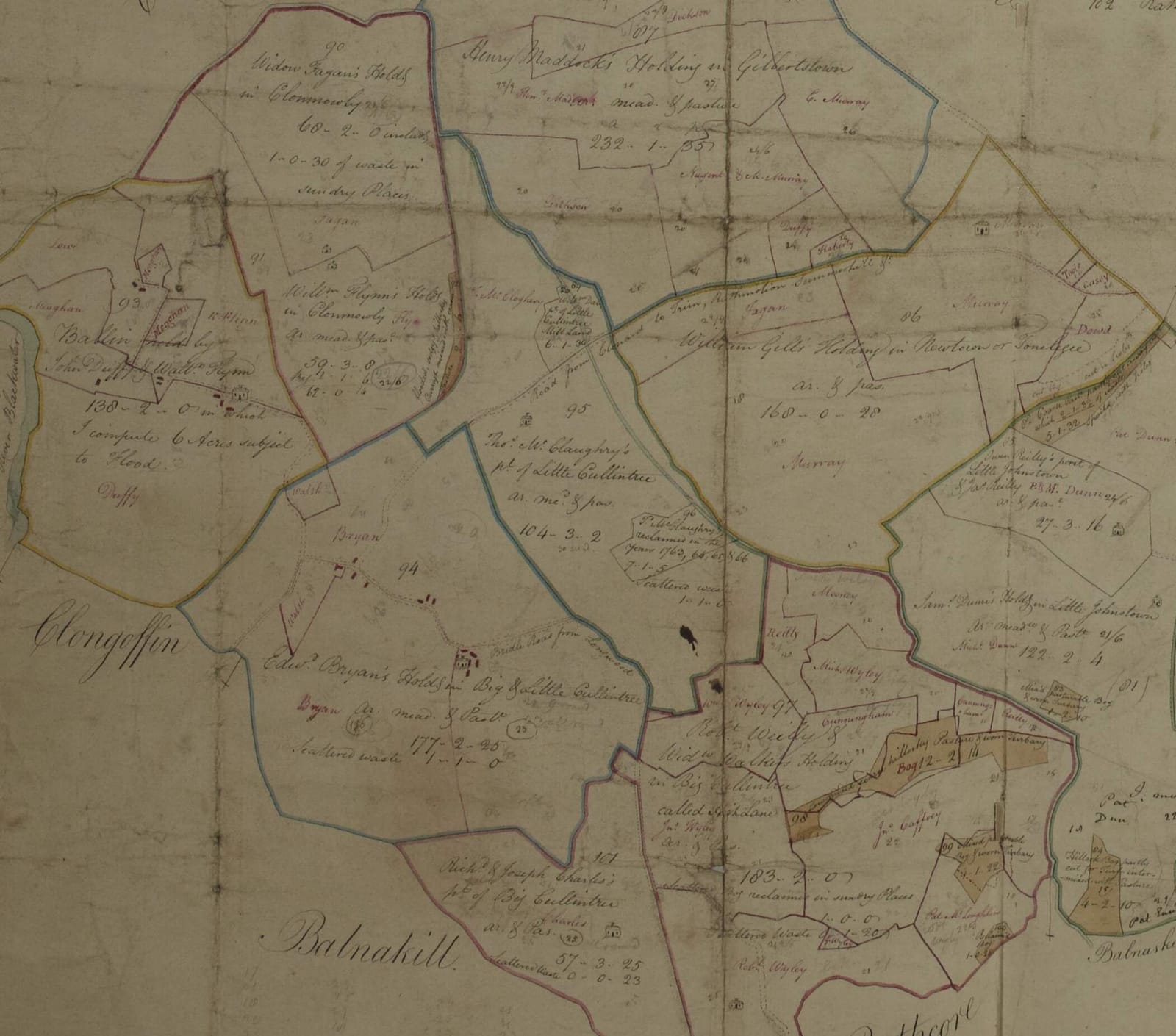
The National Library of Ireland catalogues it as “A map of lands at Clonmowley, Fordstown, Corballis, Cloncurry, Isaacstown, Cullentry, Moat, Coolderry … in the barony of Moyfenrath Lower and County of Meath. Scale 40 perches to an inch. Names of tenants and acreage of holdings shown.” It comes from the Longfield Map Collection, the office archive of a firm of Dublin land surveyors, Longfield, Murray and Brownrigg, whose maps were given to the Library by Robert Ormsby Longfield in the 1800s.
It covers the whole western half of the Rathmolyon estate: about a hundred numbered plots and roughly 4,300 acres, from the river at Longwood to the village of Rathmolyon. The surveyor wrote in the first person in one place (“in which I compute 6 Acres subject to Flood”), so this is his own working sheet, not a fair copy.
When was it drawn?
The sheet itself is undated; the Library gives it a range of 1770 to 1840. We can narrow that. Two of the tenants written in the surveyor's original hand, Joseph Charles and Thomas McClaughry, took their leases of Cullentry from the Earl of Moira in 1767 and 1771, so the map is later than 1771. A plot at Isaacstown is labelled “a Nursery planted by L[ord] Moira”, so the Rawdon family's ownership was current or fresh in memory. And the firm that kept the map, Longfield and Brownrigg, is the firm whose John Brownrigg surveyed exactly this estate in 1798 for its new owner, Robert Fowler, Archbishop of Dublin. The natural reading is that this is Brownrigg's working map for that survey.
Very likely drawn between about 1771 and 1798. Likely the 1798 Brownrigg survey specifically.
A map like this was the landlord's working tool: it recorded each tenant's holding and its acreage so that rents could be set and collected, and the names on it were kept up to date for decades, which is why later hands and inks lie over the surveyor's original. The estate changed hands while the map was in use. In 1795 the second Earl of Moira sold his Meath lands, “including principally the Rathmolyon lands”, to Robert Fowler, Archbishop of Dublin, for £62,000, and in 1798 the new owner “had a full survey of the property made, consisting of 4,416 acres”. By 1812 the estate was yielding £4,000 a year in rent; in 1836 Rathmolyon townland was “let in small farms from 21s. to 26s. per acre”, which is the range of the pencilled rents on this sheet.
The Irish acre used here, the “plantation measure”, was larger than the English statute acre: one Irish acre is about 1.62 statute acres. Acreages are written acres, roods, perches, with 4 roods to the acre and 40 perches to the rood. Griffith's Valuation of 1854 switched to statute acres, which is one reason the same farm looks bigger in later records.
Noel French, “Rathmolyon”, Meath History Hub; Irish measure. All background sources are listed on the Sources page.
Heghlane: 183 acres
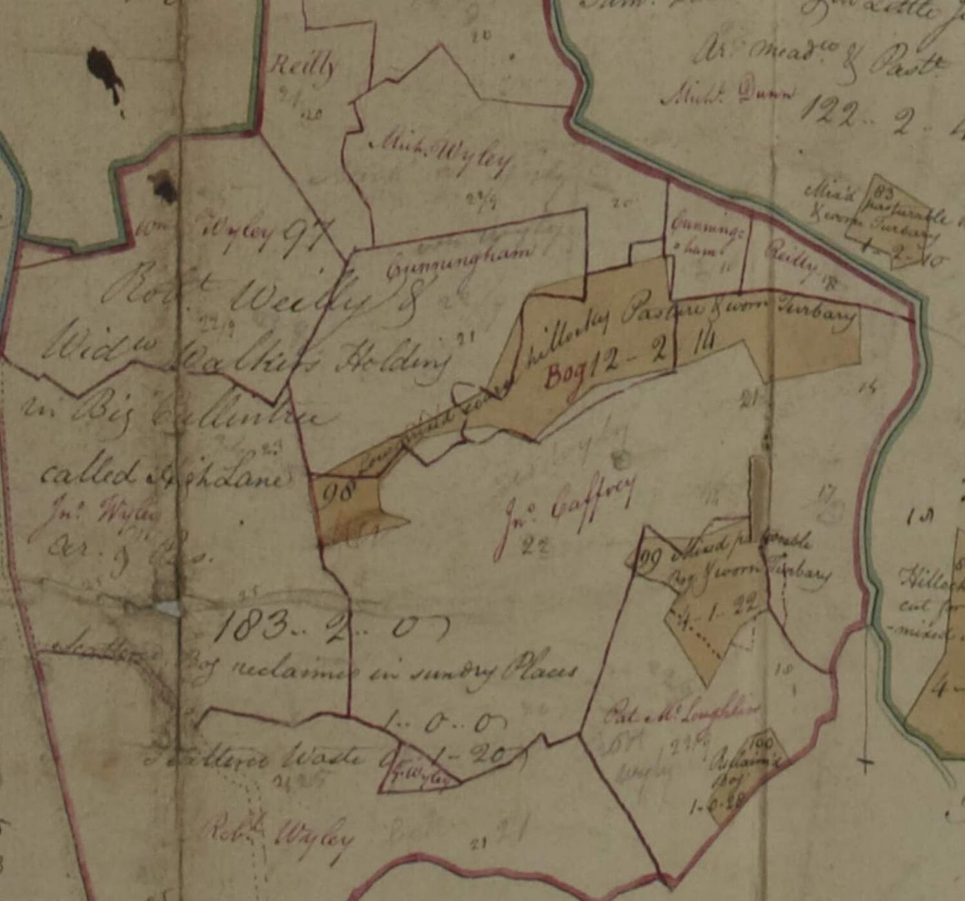
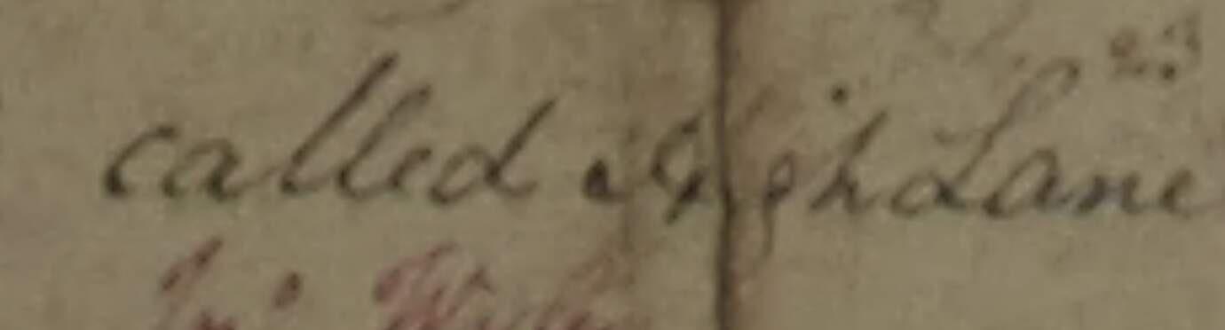
In the surveyor's own hand the farm is described in five lines:
Robt Weily & Widw Walker's Holding in Big Cullintree called Heghlane
ar. & pas. (arable and pasture)
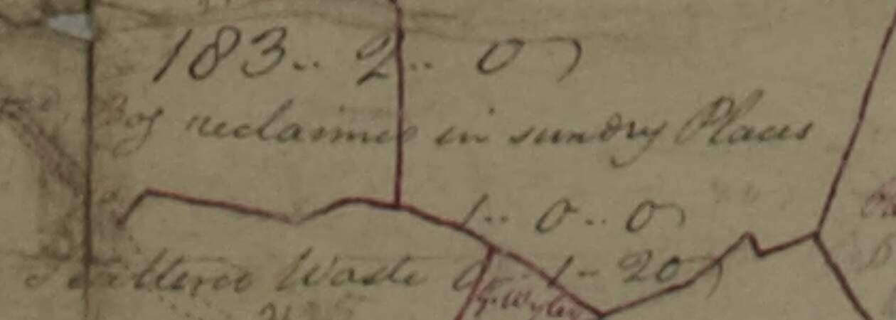
183 – 2 – 0 (183 acres 2 roods, Irish measure: nearly 300 acres in the measure we use)
scattered Bog reclaimed in sundry Places 1 – 0 – 0
scattered Waste 0 – 1 – 20
Robert Weily shared the holding with a widow named Walker. A Robert Walker also held part of Isaacstown on the same estate; whether the two families were related by marriage is a guess and nothing more. The pencil figures scattered across the farm, 21/6, 22/9, 24/6, are rents in shillings and pence per acre, added later.
The name of the farm matters. In September 2026 Chris found the Tithe Applotment Book for the parish of Rathmoylan, dated 1825, and it lists Michael Weily, William Weily Senior (twice) and William Weily Junior all at Heghlane, with a Robert Weily at Castletown and a Robert Wiely in Rathmolyon town. That pins the 1825 family to the very farm the map names.
Certain that the map says this, and that the name is Weily. Every “Reilly” on the sheet was compared letter by letter with every “Weily” and “Wyley”: the Reillys have the looped capital R of “Robt” and “Rathcore”, the Weilys the double-looped W of “Widow”, “Walker” and “Wm”. Reilly is the commonest surname in Meath, so this check had to be made, and it was made twice, here and on the 1881 civil record.
The names written in later
When the estate office updated the map, someone wrote the current tenants over the surveyor's original in red and brown ink, with plot numbers. On the Weily farm they wrote:
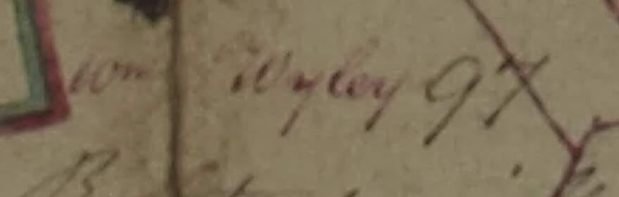
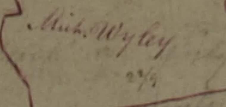
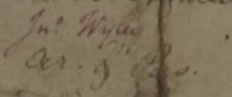
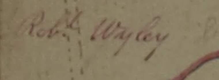
All four: National Library of Ireland, Longfield Map Collection, MS 21 F. 15 (014). A fifth, tiny “J. Wyley” sits in the scattered waste, and two faint pencil “Wyley” ghosts lie under the names Cunningham and McLoughlin.
These are the next generation of the family, and they match the 1825 tithe book: William Senior, William Junior and Michael at Heghlane, and Roberts nearby. They also match the leases the landlord's office kept: William Wiely took the big farm on 1 January 1835, and John Wielly and John Wiely took two smaller parts of Cullentry in February and June of the same year.
Just as telling is what is not on the map. Across roughly 4,300 acres and a hundred plots there is exactly one Weily household, and it is this one. Nobody of the name is at Isaacstown or Ballynaskea, where Wileys appear in 1854; those later households are this one family spreading out. One family, one farm.
Likely that the red and brown Wyleys are the generation of about 1800 to 1835. The map does not date its own annotations; the 1825 tithe book and the 1835 leases supply the dates.
The neighbours
The surveyor named every holding around the Weilys. These are the families our people would have known all their lives, worked beside, and married among.
| Plot | Holding, as written | Irish acres | Where, and why it matters |
|---|---|---|---|
| Robt Weily & Widw Walker's Holding in Big Cullintree called Heghlane | 183-2-0 | Our farm. The centre of Big Cullentry. | |
| 94 | Edwd Bryan's Holding in Big & Little Cullintree | 177-2-25 | West neighbour. The “Bridle Road from Longwood” runs through his land to the Weily farm: the road to the chapel. |
| 101 | Richd & Joseph Charles's part of Big Cullintree | 57-3-25 | South neighbour. Joseph Charles took his lease from the Earl of Moira on 21 May 1767. |
| 95 | Thos McClaughry, part of Little Cullintree | 104-3-2 | North. Leased from Lord Moira on 2 November 1771, with a map attached; the earliest map of the townland, not yet seen. |
| 96 | Peter McClaughry, “reclaimed in the years 1763, 64, 65 & 66” | 7-1-5 | Bog turned into farmland in the 1760s. |
| 89 | Wm Daly, part of Little Cullintree, Mill Land | 6-1-30 | There was a mill at Little Cullentry. A Michael Wiley married an Anne Daly a century later. |
| 98–100 | Hillocky Pasture & worn Turbary, Bog; Reclaimed Bog | 12-2-14 and less | The bog on the east side of the farm. “Turbary” is the right to cut turf for the fire. |
| Reilly, Cunningham, Jno Caffrey, Pat McLoughlin | small | Later sub-tenants or holders inside and beside the farm, in the red and brown hands. |
A farm of this size in the 1790s was not one man with a spade. Picture a long, low farmhouse of stone and thatch on the lane, a yard with a cow-house and a barn, and around it fields of oats, wheat and potatoes with cattle on the grass beyond. Robert Weily would have had labourers and perhaps a few cottier families working for him, turf drying in stacks at the edge of the bog to the east, and the widow Walker's household somewhere on the same land. Whether they were close friends, awkward partners or kin by marriage, the map cannot tell us.
The Flynns, along the road to Longwood
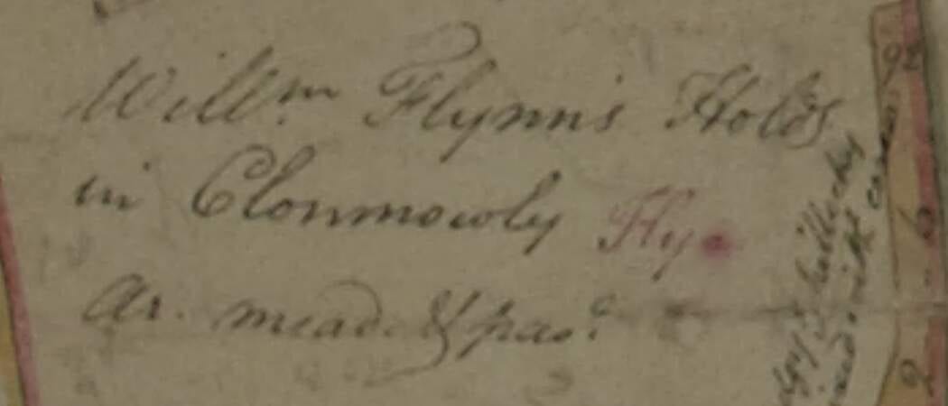
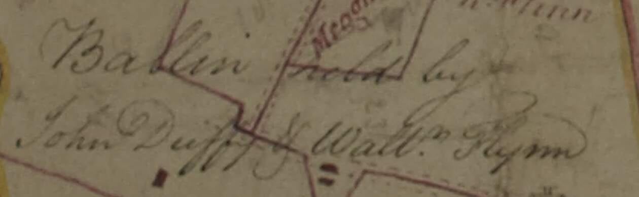
Two Flynn farms stand between the Weily farm and Longwood: William Flynn's at Clonmowley and Walter Flynn's, shared with John Duffy, at Ballin on the river. The bridle road from Longwood chapel passes them on its way to Heghlane. That is the geography behind a pattern that runs through every family record we have:
- 1842: William Weilly baptises a daughter with his wife Margaret Flynn; the sponsor is Elizabeth Flynn.
- 1853: Grace Weilly stands sponsor at a Longwood baptism beside James Flynn.
- 1854: Margaret Flynn “alias Weilly”, a widow, marries John Flynn.
- 1876: Grace Wiely marries John Brady; a witness is Mary A. Flynne.
- 1881: Grace, now a widow, marries James Byrne; a witness is Jane Flynn.
- The Longwood burial register records a “John Flynn of Clonmouly” in January 1854, a man of the Clonmowley farm.
Our own Margaret Flynn, the wife of the William who crossed in 1857, has no record of her own in Ireland. But her husband's family lived two farms from the Flynns, married Flynns twice, and had a Flynn at every wedding. Likely she was a daughter of the Clonmowley or Ballin Flynns. (For years we chased a Margaret Flynn baptised in County Limerick, 150 miles away; that lead is retired. See How We Found It.)
On a Sunday morning the Weilys of Heghlane went west along the bridle road, past Bryan's, past the Flynns at Clonmowley, and down toward the river and the chapel at Longwood. The Flynns walked the same road. Two families who met every week for a lifetime, at Mass, at funerals, at the fair: the marriages of 1842 and 1854, and whatever brought William and Margaret together in the 1850s, need no more explanation than that.
The farm through time
- 176721 May. The Earl of Moira leases part of “Cullindry” to Joseph Charles. NLI MS 43,574/4
- 17712 Nov. Lord Moira leases “Cullendragh otherwise Cullentree” to Thomas McClaughry, with a map. NLI MS 43,574/6
- 1770s–90sThe estate map. Robert Weily and Widow Walker hold Heghlane, 183 acres. NLI MS 21 F. 15 (014)
- 1798Brownrigg's survey of the estate for Archbishop Robert Fowler, the new owner. NLI MS Map 492 M, not yet seen
- 1825Tithe book. William Weily Senior, William Weily Junior and Michael Weily at Heghlane; Robert Weily at Castletown; Robert Wiely at Rathmolyon. Tithe Applotment Books, Rathmoylan
- 18351 Jan. Lease of part of Cullintre to William Wiely for two lives or 21 years at £178 1s 1d a year. Two smaller leases to John Wielly (Feb) and John Wiely (June). NLI MS 43,577/1
- 183913 Jan. Ellen, daughter of Wm Wiley and Bridget Belagh, baptised at Longwood. Longwood register
- 184128 Apr. Lease of part of Cullentre to Ellen Weily for two lives or 15 years at £172 9s 8d: the same farm, so William Senior was dead and Ellen his widow. NLI record vtls000833743
- 184225 Mar. Mary, daughter of William Weilly and Margaret Flynn, baptised at Longwood. Longwood register
- 1854Griffith's Valuation. William Wiley lot 3, Margaret Wiley lot 4, Ellen Wiley lot 5, side by side; John Wiley lots 7, 9, 10, 11; Margaret lot 18; Joseph lot 24. askaboutireland.ie
- 185422 May. Margaret Flynn “alias Weilly”, widow, marries John Flynn at Longwood. Longwood register
- 185526 Mar. Part of Cullentry re-let to Henry Purdon for 31 years. NLI MS 43,579/5
- 18561 Jan and 28 Apr. The 21 years of William's lease and the 15 years of Ellen's run out. With the named lives dead, the farm falls back to the landlord. Inference from the lease terms
- 1857William Wiley, Margaret Flynn and baby William are in America. 1900 census, St Louis
- 186130 Oct. John Weilly takes a new lease of part of Cullentry for 31 years at £105. The line that stayed. NLI record vtls000833755
- 1871–76Michael Wiley and Anne Daly baptise John, Mary, Elizabeth and Hugh at Longwood. Longwood register
- 18814 Jul. Grace Weily, farmer's widow of Cullentry, daughter of the late William Weily, marries James Byrne. Civil record, Trim
How the 1835 lease and the map fit together
The map gives rents of about 21 to 24 shillings an acre in pencil. At those rates, £178 a year buys about 150 to 165 Irish acres. Robert Weily's farm was 183 acres, of which some was bog and waste. Very likely William Wiely's 1835 lease was of Robert's farm, Heghlane.
What the map does not tell us
- It does not name William Wiley I, the man who crossed in 1857, or give any date for his birth. He was probably born about 1835, well after the surveyor's visit and before the tithe book's Williams had grown old.
- It does not date the red, brown and pencil additions. Their order is visible (pencil under red, red over the original) but not their years.
- It does not say how Robert Weily was related to the William Senior of 1825. Likely grandfather or father: same farm, same rare spelling, the only family of the name on the estate. But that is inference, not a record.
- It does not by itself connect the Springfield family to Cullentry. That link rests on Grace Weily's 1881 marriage record, the DNA of her descendants, and the 1842 baptism. What the map adds is that there was no other Weily family in the district for those records to belong to.
See it yourself
The National Library of Ireland has digitised the whole sheet. Open the catalogue record and use the viewer to zoom anywhere; look for “Rathcore” near the bottom left, then just above it. A second sheet in the same collection, MS 21 F. 15 (035), covers the eastern half of the estate and has no Cullentry on it.